
| Area | South Fork Big River |
| Topic | Sediment: Fines <5.6mm from Daugherty Creek 2000 |
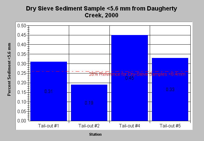
| Caption: The chart above shows percent fine sediment levels <5.6mm from dry-sieved McNeil samples in Daugherty Creek, 2000. Fine sediment was above the adjusted dry-sieve target of 26% in all tailouts, excluding #2. The reference value of 26% represents a target for dry-sieved samples based on the Big River TMDL and Sharazi and Seim (1979). This adjustment is not necessarily recognized by the EPA. The 6.4mm class size was not reported by MRC. The charted < 5.6mm values are conservative in comparison to the target because they do not include fines between 5.6 and 6.4mm. Data provided by the Mendocino Redwood Company. See Info Links for more information. Click on Picture to see a map of MRC Big River monitoring locations. | |
 |
To learn more about this topic click here .
To view the table with the chart's data, click Chart Table web page.
To download the table with the chart's data, click daugherty_mcneil.dbf (size 2,046 bytes) .
To see meta information about the data table used for this topic click here
To view the table with the chart's source data, click Source Table web page.
To download the table with the chart's source data, click big_mcneil.dbf (size 6,218 bytes)
| www.krisweb.com |