
| Area | Blue Waterhole Creek |
| Topic | Land Cover: USFS Veg Size for Victoria Fork 1994 |
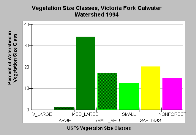
| Caption: This bar chart shows vegetation size classes in the Victoria Fork Calwater Planning Watershed, which is actually the Blue Waterhole Creek basin. This planning watershed had 35% of vegetation in medium-large and greater trees, 50% in small-medium and smaller trees and 15% in non-forest. The predominance of small trees and non-forest is at least in part owing to natural grasslands that occur within the Blue Waterhole Creek basin, although timber harvest in some areas may also be partly responsible for small tree diameters. The information was derived from a 1994 Landsat image by the U.S. Forest Service. This analysis technique calculates averages of vegetation stands at a one-hectare scale, and therefore is accurate at the stand rather than individual tree level. Click on InfoLinks for more information. Vegetation is classified according to diameter at breast height (DBH): Very Large = 40-50" DBH, Large = 30-39.9" DBH, Medium/Large = 20-29.9" DBH, Small/Medium = 12-19.9" DBH, Small = 5-11.9" DBH, Saplings = 1-4.9" DBH, Non-Forest = No trees, shrubs, grass, bare soil. | |
 |
To learn more about this topic click Info Links .
To view additional information (data source, aquisition date etc.) about this page, click Metadata .
To view the table with the chart's data, click Chart Table web page.
To download the table with the chart's data, click veg_usfs_garcia.dbf (size 2,368 bytes) .
To view the table with the chart's source data, click Source Table web page.
To download the table with the chart's source data, click veg_usfs_garcia_source.dbf (size 2,609 bytes)
| www.krisweb.com |