
| Area | Basin-wide/General |
| Topic | Climate: Annual Rainfall - Garcia Basin, 1910-2000 |
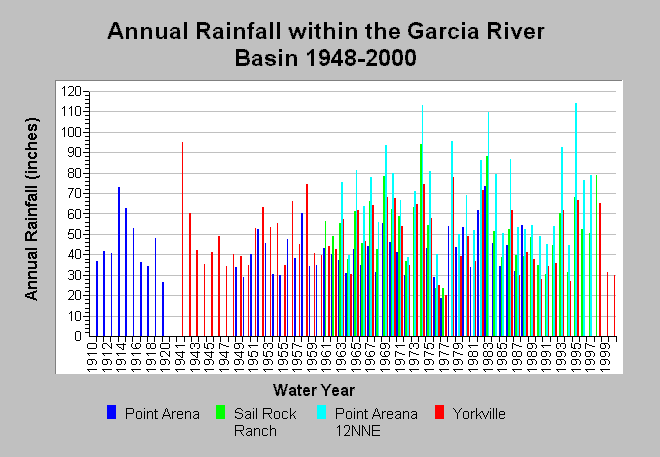
| Caption: This chart shows annual rainfall accumulation recorded at four rain gages within the Garcia River basin between water years 1910 to 2000, missing 1921-1940. Individual rain gages also contain data gaps. The rain gages shown are located at directional extremities and include: Point Arena (DWR # F80 7009 00), Sail Rock Ranch (DWR # F80 7639 50), Point Arena 12NNE (DWR # F80 7009 50), and Yorkville (DWR # F80 9851 00). Spatial variations in annual rainfall can bee seen; for example, the Point Arena coastal rain gage accumulates less rainfall than the inland rain gages at higher elevations, such as Yorkville. Click the Map tab to view the rain gage locations. Rainfall measurements are by water year. Data are compiled by the California Department of Water Resources. See InfoLinks for more information. | |
 |
To learn more about this topic click Info Links .
To view additional information (data source, aquisition date etc.) about this page, click Metadata .
To view the table with the chart's data, click Chart Table web page.
To download the table with the chart's data, click climate_rainfall_annual_garciaregion.dbf (size 3,506 bytes) .
| www.krisweb.com |