
| Area | Basin-wide/General |
| Topic | Flow: Garcia River - Monthly Average 1963-1983 |
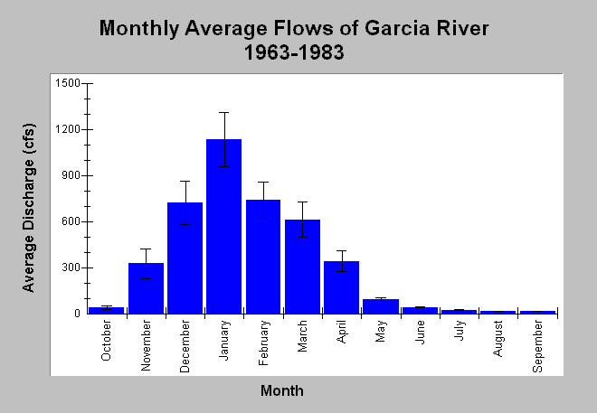
| Caption: This chart displays monthly average discharge (cfs) of the Garcia River between water years 1963 to 1983. High flows occur during winter months in response to storm events and high base flows. Lower flows occur between June through October with average monthly stream flow less than 45 cfs. Whiskers bracket one standard error from the mean. Monthly average flows are compiled by the US Geological Survey from stream flow measurements gathered at USGS gage #11467600 between water years 1963 and 1983. The stream gage was discontinued after 1983. See InfoLinks for more information. | |
 |
To learn more about this topic click Info Links .
To view additional information (data source, aquisition date etc.) about this page, click Metadata .
To view the table with the chart's data, click Chart Table web page.
To download the table with the chart's data, click flow_garcia_monthlyave_1963_1983.db (size 4,096 bytes) .
To view the table with the chart's source data, click Source Table web page.
To download the table with the chart's source data, click flow_garcia_monthly_1963_1983.dbf (size 3,014,804 bytes)
| www.krisweb.com |