
| Area | Basin-wide/General |
| Topic | Sediment: Road Densities by Calwater (O'Connor) 1998 for Garcia Basin |
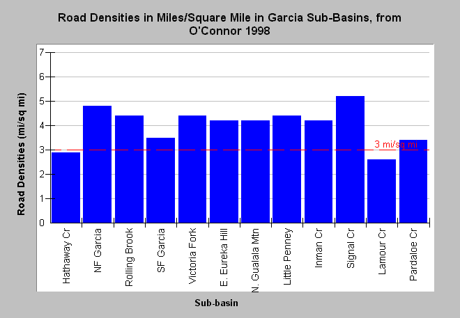
| Caption: The chart displays road densities as reported by O'Connor (1998). O'Connor took data originating from CDF GIS database which is based on information from THPs collected since 1986. Since THP data do not cover entire sub-basin areas, road density data are likely incomplete and road densities are underestimates. Most reported densities exceed properly functioning condition according to the National Marine Fisheries Service (1996), which is less than 3 miles per square mile, a value shown for reference. Cedarholm, et al. (1981) suggests that road densities should not exceed 1.6 mi/sq. mi. to keep fine sediment in streams at suitable levels for salmonid spawning. Click on InfoLinks for more background information. | |
 |
To learn more about this topic click Info Links .
To view additional information (data source, aquisition date etc.) about this page, click Metadata .
To view the table with the chart's data, click Chart Table web page.
To download the table with the chart's data, click road_density_misqmi_allbasins.dbf (size 410 bytes) .
| www.krisweb.com |