
| Area | Basin-wide/General |
| Topic | Sediment: Road Densities by Calwater (CDF) 2001 for KRIS Garcia Area |
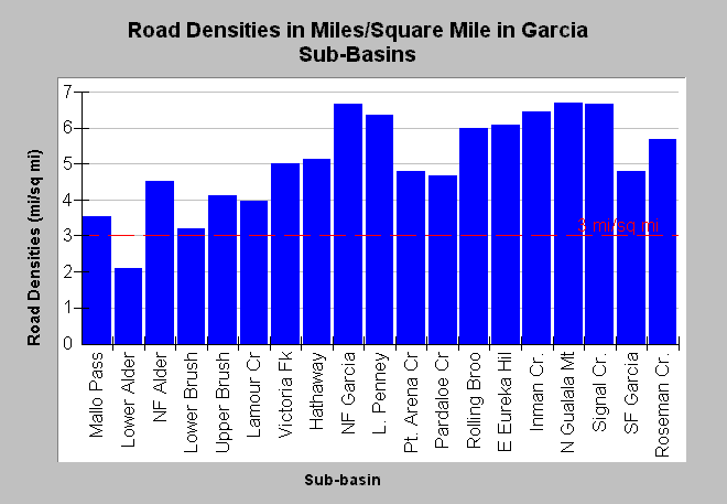
| Caption: This chart displays road densities by Calwater Planning Watershed as reported by the California Department of Forestry, which has updated electronic maps associated with timber harvests in the Garcia River basin and adjacent coastal sub-basins through 2001. Most reported densities exceed properly functioning condition according to the National Marine Fisheries Service (1996), which is less than 3 miles per square mile (mi/sq mi), a value shown for reference. The highest road densities with near or over 6.5 mi/sq mi were in the North Fork Garcia, Signal Creek, mainstem Garcia River below Signal Creek (N Gualala Mt), and Inman Creek. Click on InfoLinks for more background information. | |
 |
To learn more about this topic click Info Links .
To view additional information (data source, aquisition date etc.) about this page, click Metadata .
To view the table with the chart's data, click Chart Table web page.
To download the table with the chart's data, click road_dens_cw_paul.dbf (size 1,080 bytes) .
| www.krisweb.com |