
|
Area/Topic | Bibliography | Background | Hypotheses | Home |
|
Map Page.
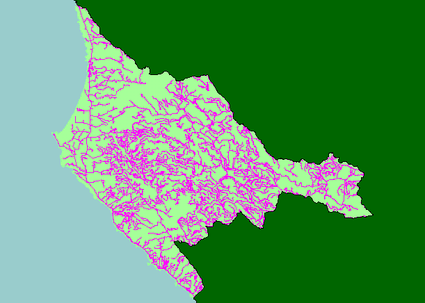
You selected the area Basin-wide/General and the topic Map: 1F Roads, Garcia Project Area |
| This is a map of the Roads in the KRIS Garcia project area. The roads data may under-represent actual roads as USGS maps are only updated periodically and may not have newly constructed roads. Note that areas in the North Fork have a higher density of roads, which is because the California Department of Forestry has updated road maps associated with timber harvest. Greater road densities are related to increased fine sediment yield to streams. Data were contributed by the California Department of Forestry and the U.S. Geologic Survey. Scale = 1:328,604 . | |||
|
|
||
To view metadata about a map layer, click on a link in the table below.
| Name of Layer in Map Legend | Metadata File Name |
|---|---|
| Project Frame | Unavailable |
| Roads (1:24k scale) | roads24.shp.txt |
| THP Roads (1:24k)(CDF) | roads_thp.shp.txt |
| Topo Map (1:24k scale)(USGS) | Unavailable |
| Cold Spring, DOQ | coldspring.sid.txt |
| Eureka Hill, DOQ | eurekahill.sid.txt |
| Gualala, DOQ | gualala.sid.txt |
| Mallo Pass Creek, DOQ | mallopass.sid.txt |
| Ornbaun Valley, DOQ | ornbaun.sid.txt |
| Point Arena, DOQ | pointarena.sid.txt |
| Saunders Reef, DOQ | saundersreef.sid.txt |
| Gube Mountain, DOQ | gubemtn.sid.txt |
| Mcguire Ridge, DOQ | mcguire.sid.txt |
| Zeni Ridge, DOQ | zeniridge.sid.txt |
| Grayscale Hillshade (TIFF) | grayscale.tif.txt |
| Project Background | Unavailable |
| www.krisweb.com |