
| Area | Coastal Tributaries North |
| Topic | Sediment: Road Densities Coastal No. Calwater Planning Watersheds 2001 |
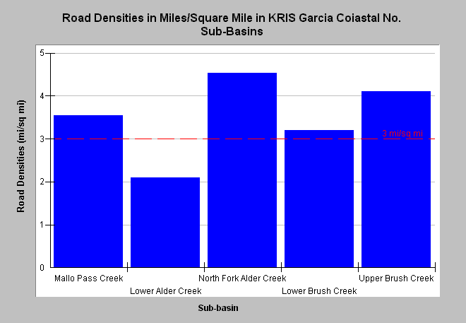
| Caption: This chart displays road densities of the KRIS Garcia projects Coastal Tributaries North sub-basin by Calwater Planning Watershed as reported by the California Department of Forestry. CDF has updated electronic maps associated with timber harvests in the Garcia River basin and adjacent coastal sub-basins. All basins except for Lower Alder Creek had densities exceeding properly functioning condition according to the National Marine Fisheries Service (1996), which is less than 3 miles per square mile (mi/sq mi), a value shown for reference. There are roads clearly visible in aerial photographs that are not part of the GIS roads layer from which these data were derived. The upper watersheds of Alder Creek and Brush Creek are very steep and roads may pose risk of triggering debris torrents. Click on InfoLinks for more background information. See the Map tab for spatial data. | |
 |
To learn more about this topic click Info Links .
To view additional information (data source, aquisition date etc.) about this page, click Metadata .
To view the table with the chart's data, click Chart Table web page.
To download the table with the chart's data, click road_dens_cn_cdf.dbf (size 1,080 bytes) .
| www.krisweb.com |