
|
Area/Topic | Bibliography | Background | Hypotheses | Home |
|
Map Page.
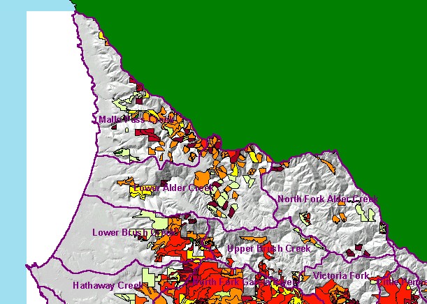
You selected the area Coastal Tributaries North and the topic Map: 1GTimber Harvest, Coastal Tribs North |
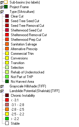
| This is a map of timber harvest layers in the KRIS Garcia Coastal Streams North sub-basin area, overlaid on top of Calwater Planning Watersheds and an elevation hillshade. Data were provided by the California Department of Forestry and show only harvests permitted between 1987 and 2001. Harvests are significant in this time frame in Brush, Alder and Mallo Pass creeks, especially when considering that many harvests are on steep terrain. | |||
|
|
||
To view metadata about a map layer, click on a link in the table below.
| Name of Layer in Map Legend | Metadata File Name |
|---|---|
| Calwater PWS (w/ labels) | calw22.shp.txt |
| Sub-basins (no labels) | subbasins.shp.txt |
| Project Frame | Unavailable |
| Type (Silviculture) | thpcwrgns.shp.txt |
| Topo Map (1:24k scale)(USGS) | Unavailable |
| Grayscale Hillshade (TIFF) | grayscale_light.tif.txt |
| Landslide Potential (Shalstab) [TIFF] | garciaqt.tif.txt |
| Relative Landslide Potential (Shalstab) [TIFF] | garciaqt2.tif.txt |
| Percent Slope, Hillshade (TIFF) | slope1.tif.txt |
| Elevation (10 m resolution)(TIFF) | elev10.tif.txt |
| www.krisweb.com |