
| Area | Coastal Tributaries South |
| Topic | Climate: Annual Rainfall - Sail Rock Ranch, 1910-1998 |
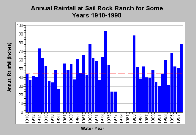
| Caption: This chart shows annual rainfall accumulation at the Sail Rock Ranch rain gage (DWR # F80 7639 50) between 1910 and 1998, missing water years 1921-1960 and 1978-1982. This gage is just outside the South Fork Garcia basin to the west (see Map). Rainfall measurements are by water year (Oct 1- Sept 30). For the period of record, the minimum total rainfall accumulation occurred in 1977 (23.69 inches) and the maximum during 1972 (93.94 inches). The latter is shown by a dashed green line while the median rainfall is represented by a dashed red line (approximately 44 inches). Data are compiled by the California Department of Water Resources. See InfoLinks for more information. | |
 |
To learn more about this topic click Info Links .
To view additional information (data source, aquisition date etc.) about this page, click Metadata .
To view the table with the chart's data, click Chart Table web page.
To download the table with the chart's data, click climate_rainfall_annual_sailrockranch.dbf (size 1,198 bytes) .
| www.krisweb.com |