
| Area | Coastal Tributaries South |
| Topic | Land Cover: USFS Veg Size in Riparian for Roseman Creek 1994 |
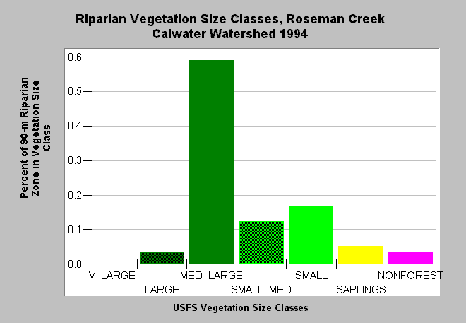
| Caption: This bar chart shows vegetation size classes in the riparian zone of the Roseman Creek Calwater Planning Watershed. The riparian zone encompasses a distance of 90 meters (300 feet) on either side of the stream channel. This planning watershed had 62% of the riparian in medium-large and greater trees, 32% in small-medium and smaller trees and 3% in non-forest. The information was derived from a 1994 Landsat image by the U.S. Forest Service. This analysis technique calculates averages of vegetation stands at a one-hectare scale, and therefore is accurate at the stand rather than individual tree level. Click on InfoLinks for more information. Click on the Map tab to see spatial data. Vegetation is classified according to diameter at breast height (DBH): Very Large = 40-50" DBH, Large = 30-39.9" DBH, Medium/Large = 20-29.9" DBH, Small/Medium = 12-19.9" DBH, Small = 5-11.9" DBH, Non-Forest = No trees, shrubs, grass, bare soil. | |
 |
To learn more about this topic click Info Links .
To view additional information (data source, aquisition date etc.) about this page, click Metadata .
To view the table with the chart's data, click Chart Table web page.
To download the table with the chart's data, click veg_usfs_rip_garcia.dbf (size 2,326 bytes) .
To view the table with the chart's source data, click Source Table web page.
To download the table with the chart's source data, click veg_usfs_rip_garcia_source.dbf (size 2,647 bytes)
| www.krisweb.com |