
| Area | Lower Garcia / Estuary |
| Topic | Land Cover: USFS Veg Size in Riparian for Hathaway Creek 1994 |
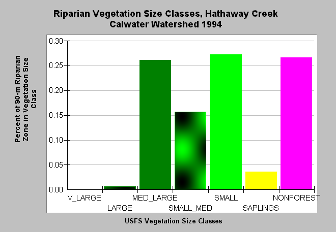
| Caption: This bar chart shows vegetation size classes in the riparian zone of the Hathaway Creek Calwater Planning Watershed, which is synonymous with the KRIS Lower Garcia/Estuary sub-basin. The riparian zone encompasses a distance of 90 meters (292.5 feet) on either side of the stream channel. This planning watershed had 27% of the riparian in medium-large and greater trees, 47% in small-medium and smaller trees and 27% in non-forest. Lower Hathaway Creek runs through wetlands which are not forested. Note that larger diameter trees are much more prevalent than in upland areas (see next Topic). Click on InfoLinks for more information. Data derived from a 1994 Landsat image by the U.S. Forest Service Spatial Analysis Lab, Sacramento, CA. Vegetation is classified according to diameter at breast height (DBH): Very Large = 40-50" DBH, Large = 30-39.9" DBH, Medium/Large = 20-29.9" DBH, Small/Medium = 12-19.9" DBH, Small = 5-11.9" DBH, Non-Forest = No trees, shrubs, grass, bare soil. | |
 |
To learn more about this topic click Info Links .
To view additional information (data source, aquisition date etc.) about this page, click Metadata .
To view the table with the chart's data, click Chart Table web page.
To download the table with the chart's data, click veg_usfs_rip_garcia.dbf (size 2,326 bytes) .
To view the table with the chart's source data, click Source Table web page.
To download the table with the chart's source data, click veg_usfs_rip_garcia_source.dbf (size 2,647 bytes)
| www.krisweb.com |