
| Area | Lower Garcia / Estuary |
| Topic | Stream Channel: Cross-Sections - Garcia Estuary XS-5, 1991-1998 |
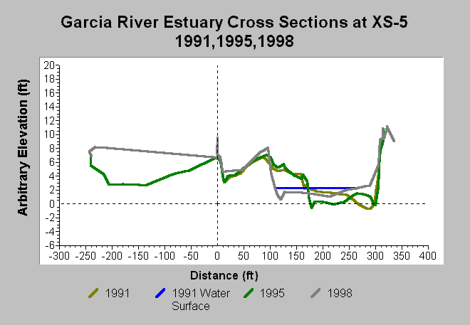
| Caption: This chart shows surveys of the Garcia River Estuary cross-section XS-5. Surveys were conducted in 1991, 1995, and 1998. Jackson (1998) noted that: "By 1995, a shoal had replaced the thalweg by the right bank. The thalweg had shifted to the left bank but stayed at the same elevation of -0.6 feet. There was some minor deposition on the left bank. By 1998, the width of the low-flow channel had widened over 50 feet. Material had been deposited across the entire channel bottom causing the thalweg to rise 1.1 feet to an elevation of +0.7 feet. The channel widened at the expense of the left bank bar. The area of the cross section (Table 1) increased slightly between 1991 and 1995 indicating net erosion of material from the cross section. By 1998 the area decreased to just slightly less than its 1991 value, indicating a small net deposition for the 1991 to 1998 period." Data are from Jackson (1998). See InfoLinks for more information. | |
 |
To learn more about this topic click Info Links .
To view additional information (data source, aquisition date etc.) about this page, click Metadata .
To view the table with the chart's data, click Chart Table web page.
To download the table with the chart's data, click xs_garcia_estuary_xs5_1991_1998.dbf (size 6,984 bytes) .
| www.krisweb.com |