
| Area | Lower Garcia / Estuary |
| Topic | Stream Channel: Cross-Sections - Garcia at Hooper XS-1, 1991-1998 |
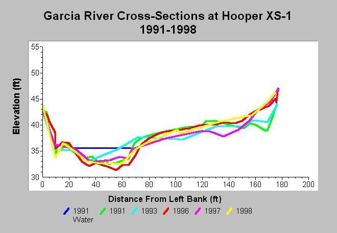
| Caption: This chart shows Garcia River cross-section surveys conducted between 1991 and 1998 at the Hooper XS-1 cross-section, located on the Hooper property (Oz). The channel width decreased between 1991 and 1993; some scour occurred on the point bar. The channel scoured and deposition occurred on the point bar between 1993 and 1996 and between 1997 and 1998. The thalweg aggraded and the point bar scoured between 1996 and 1997. Clay was exposed on the right margin of the channel bottom in 1996 and then buried in 1997. Deposition occurred on the point bar and in the channel by 1998. The result was a diminishment of fish habitat at this location between 1996 and 1997, as depths dropped below three feet. Data are from Mendocino County Water Agency. See InfoLinks for more information. | |
 |
To learn more about this topic click Info Links .
To view additional information (data source, aquisition date etc.) about this page, click Metadata .
To view the table with the chart's data, click Chart Table web page.
To download the table with the chart's data, click xs_garcia_hooper_xs1_1991_1998.dbf (size 8,638 bytes) .
| www.krisweb.com |