
| Area | Lower Garcia / Estuary |
| Topic | Stream Channel: Cross-Sections - Garcia at Kendall Upper-2, 1991-1998 |
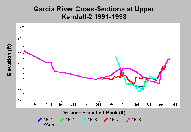
| Caption: This chart shows Garcia River cross-section surveys conducted at the Upper Kendall-2 cross-section, located on the Kendall property, between 1991 and 1998. Significant bed aggradation and widening is seen in the 1997 cross-section survey. This aggradation is attributed to large storm events in 1995 and 1997 that reportedly caused large areas of bank erosion upstream of the cross-section (Jackson 1997). More aggradation occurred by 1998 and the thalweg moved towards the right bank. The 1998 survey notes state that the ground was disturbed by heavy machinery between 115 ft and 400 ft. Data are from Mendocino County Water Agency. See InfoLinks for more information. | |
 |
To learn more about this topic click Info Links .
To view additional information (data source, aquisition date etc.) about this page, click Metadata .
To view the table with the chart's data, click Chart Table web page.
To download the table with the chart's data, click xs_garcia_kendall_up_1991_1998.dbf (size 11,458 bytes) .
| www.krisweb.com |