
| Area | Lower Garcia / Estuary |
| Topic | Water Quality: Salinity in Garcia Estuary by Station June-August 1995 |
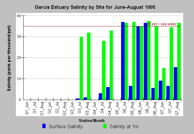
| Caption: The chart above shows the salinity at the surface and one meter in depth at all stations sampled by Higgins (1995) in the Garcia River estuary once monthly from June to August 1995. Salinity never extended upstream to the Bend Hole (G1) or the site just downstream (G2). Stations G3, G4 and G5 were fresh water dominated in June 1995 but became increasingly dominated by salt water through August. Surface samples are influenced by the tide, so even site G6 at the mouth of the estuary had less than full strength sea water (35 ppm) at the surface in August due to low tide. See InfoLinks for more information on methods or study results of Higgins (1996). | |
 |
To learn more about this topic click Info Links .
To view additional information (data source, aquisition date etc.) about this page, click Metadata .
To view the table with the chart's data, click Chart Table web page.
To download the table with the chart's data, click estuary_salinity_chart.dbf (size 1,168 bytes) .
To view the table with the chart's source data, click Source Table web page.
To download the table with the chart's source data, click estuary_1995_data_source.dbf (size 5,094 bytes)
| www.krisweb.com |