
|
Area/Topic | Bibliography | Background | Hypotheses | Home |
|
Map Page.
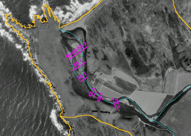
You selected the area Lower Garcia / Estuary and the topic Stream Channel: Cross-Sections - Garcia Estuary Mouth XS-2, 1991-1998 |
| This is a map of Dennis Jackson's 1998 cross-sections (red lines) in the Garcia estuary, overlaid on top of KRIS sub-basins, 1:24,000 scale streams, and a digital orthophoto quadrangle (DOQ). Cross-sections locations were hand-digitized, and should not be considered perfectly accurate. | |||
|
|
||
To view metadata about a map layer, click on a link in the table below.
| Name of Layer in Map Legend | Metadata File Name |
|---|---|
| Estuary Cross-Sections (1998) | jackson_est_xs.shp.txt |
| Sub-basins (no labels) | subbasins.shp.txt |
| Streams (1:24k scale)(no labels) | streams24.shp.txt |
| Project Frame | Unavailable |
| Elevation (10 m resolution)(TIFF) | elev10.tif.txt |
| Topo Map (1:24k scale)(USGS) | Unavailable |
| PointArena DOQ | pointarena.sid.txt |
| Project Background | Unavailable |
| www.krisweb.com |