
| Area | Middle Garcia |
| Topic | Land Cover: USFS Veg Size for East of Eureka Hill 1994 |
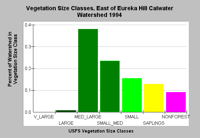
| Caption: This bar chart shows vegetation size classes in the East of Eureka Hill Calwater Planning Watershed. This planning watershed had 39% of vegetation in medium-large and greater trees, 52% in small-medium and smaller trees and 9% in non-forest. The predominance small tree size classes in an area with few grass or oak woodlands indicate active, recent logging. The information was derived from a 1994 Landsat image by the U.S. Forest Service. This analysis technique calculates averages of vegetation stands at a one-hectare scale, and therefore is accurate at the stand rather than individual tree level. Click on InfoLinks for more information. Vegetation is classified according to diameter at breast height (DBH): Very Large = 40-50" DBH, Large = 30-39.9" DBH, Medium/Large = 20-29.9" DBH, Small/Medium = 12-19.9" DBH, Small = 5-11.9" DBH, Saplings = 1-4.9" DBH, Non-Forest = No trees, shrubs, grass, bare soil. | |
 |
To learn more about this topic click Info Links .
To view additional information (data source, aquisition date etc.) about this page, click Metadata .
To view the table with the chart's data, click Chart Table web page.
To download the table with the chart's data, click veg_usfs_garcia.dbf (size 2,403 bytes) .
To view the table with the chart's source data, click Source Table web page.
To download the table with the chart's source data, click veg_usfs_garcia_source.dbf (size 2,609 bytes)
| www.krisweb.com |