
|
Area/Topic | Bibliography | Background | Hypotheses | Home |
|
Map Page.
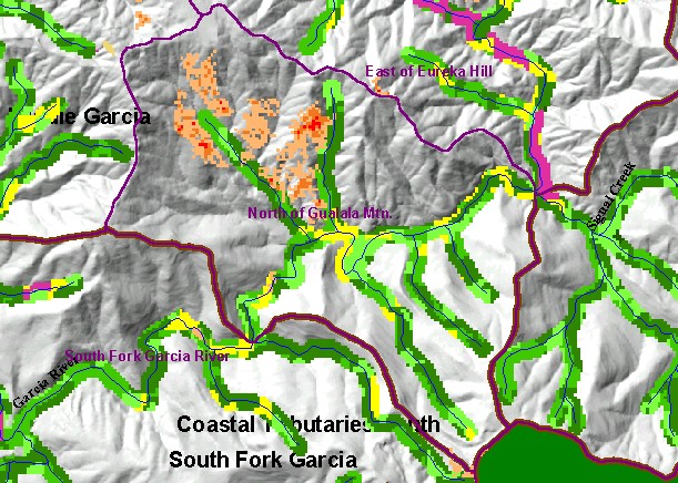
You selected the area Middle Garcia and the topic Land Cover: USFS Veg Size in Riparian for North of Gualala Mtn. 1994 |
| This is a map of vegetation size data within 90-meter riparian buffer zones in the North of Gualala Mountain Calwater Planning Watershed with KRIS sub-basins, a Grayscale Hillshade, 1:24,000 USGS hydrography and 1994 to 1998 change scene detection derived from Landsat imagery. The tree size classifications were derived from Landsat multi-spectral images taken in 1994. Stand conditions are accurately represented at the one hectare scale. Active logging in riparian zones is reflected in small tree diameters along tributaries and when viewing the change scene data. Data were provided by the U.S. Forest Service Pacific Southwest Region Remote Sensing Lab and the California Department of Forestry. Available layers include Vegetation Size and Topographic Map. Scale = 1:42,127 . | |||
|
|
||
To view metadata about a map layer, click on a link in the table below.
| Name of Layer in Map Legend | Metadata File Name |
|---|---|
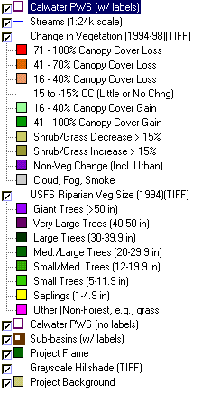
| Calwater PWS (w/ labels) | calw22.shp.txt |
| Streams (1:24k scale) | streams24.shp.txt |
| Change in Vegetation (1994-98)(TIFF) | vegchg.tif.txt |
| USFS Riparian Veg Size (1994)(TIFF) | vegsizebuf.tif.txt |
| USFS Vegetation Size (1994)(TIFF) | vegsize.tif.txt |
| Calwater PWS (no labels) | calw22.shp.txt |
| Sub-basins (w/ labels) | subbasins.shp.txt |
| Project Frame | Unavailable |
| Topo Map (1:24k scale)(USGS) | Unavailable |
| Grayscale Hillshade (TIFF) | grayscale_light.tif.txt |
| Project Background | Unavailable |
| www.krisweb.com |