
|
Area/Topic | Bibliography | Background | Hypotheses | Home |
|
Map Page.
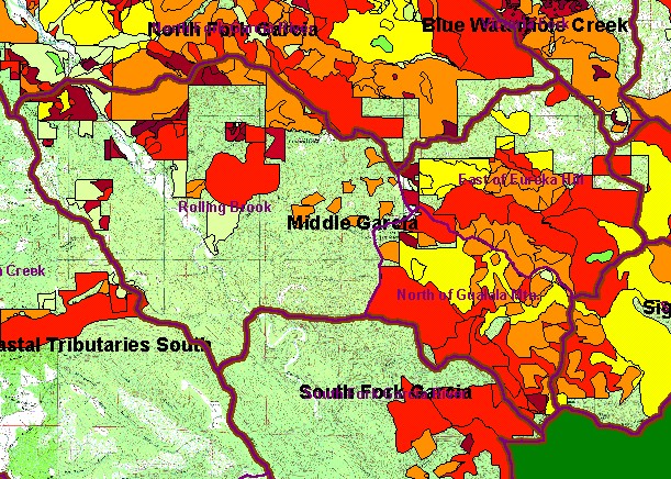
You selected the area Middle Garcia and the topic Map: 1F Timber Harvest 1987-2002, Middle Garcia Sub-basin |
| This is a map of timber harvests permitted by the California Department of Forestry (CDF) in the Middle Garcia KRIS sub-basin between 1987 and 2002. There has been very widespread timber harvest In the North Gualala Mountain and East of Eureka Hill Calwater Planning Watersheds, while there has been comparatively little activity in Rolling Brook. Data were provided by the California Department of Forestry, Santa Rosa. Scale = 1:86,837 . | |||
|
|
||
To view metadata about a map layer, click on a link in the table below.
| Name of Layer in Map Legend | Metadata File Name |
|---|---|
| Calwater PWS (w/ labels) | calw22.shp.txt |
| Sub-basins (no labels) | subbasins.shp.txt |
| Sub-basins (w/ labels) | subbasins.shp.txt |
| Change in Vegetation (1994-98)(TIFF) | vegchg.tif.txt |
| Timber Harvest Permits 1987-2002 | silvicul87_01.shp.txt |
| USFS Riparian Veg Size (1994)(TIFF) | vegsizebuf.tif.txt |
| USFS Vegetation Size (1994)(TIFF) | vegsize.tif.txt |
| Project Frame | Unavailable |
| Topo Map (1:24k scale)(USGS) | Unavailable |
| Grayscale Hillshade (TIFF) | grayscale_light.tif.txt |
| Project Background | Unavailable |
| www.krisweb.com |