
| Area | Mill/Pardaloe Creeks |
| Topic | Land Cover: USFS Veg Size for Pardaloe Creek 1994 |
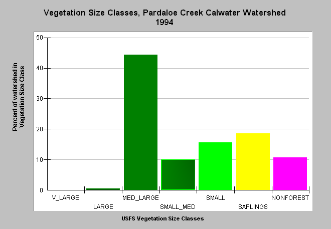
| Caption: This bar chart shows vegetation size classes in the Pardaloe Creek Calwater Planning Watershed. This planning watershed had 45% of vegetation in medium-large and greater trees, 44% in small-medium and smaller trees and 11% in non-forest. Mťlange terrain in this sub-basin gives rise to natural grasslands and oak woodlands, which account for some of the Non-Forest and smaller tree sizes. The information was derived from a 1994 Landsat image by the U.S. Forest Service. This analysis technique calculates averages of vegetation stands at a one-hectare scale, and therefore is accurate at the stand rather than individual tree level. Click on InfoLinks for more information. Click on the Map tab to see spatial data. Vegetation is classified according to diameter at breast height (DBH): Very Large = 40-50" DBH, Large = 30-39.9" DBH, Medium/Large = 20-29.9" DBH, Small/Medium = 12-19.9" DBH, Small = 5-11.9" DBH, Saplings = 1-4.9" DBH, Non-Forest = No trees, shrubs, grass, bare soil. | |
 |
To learn more about this topic click Info Links .
To view additional information (data source, aquisition date etc.) about this page, click Metadata .
To view the table with the chart's data, click Chart Table web page.
To download the table with the chart's data, click veg_usfs_garcia.dbf (size 2,368 bytes) .
To view the table with the chart's source data, click Source Table web page.
To download the table with the chart's source data, click veg_usfs_garcia_source.dbf (size 2,609 bytes)
| www.krisweb.com |