
| Area | North Fork Garcia |
| Topic | Stream Channel: Cross-Sections - Garcia at Conner Hole, 1956-2002 |
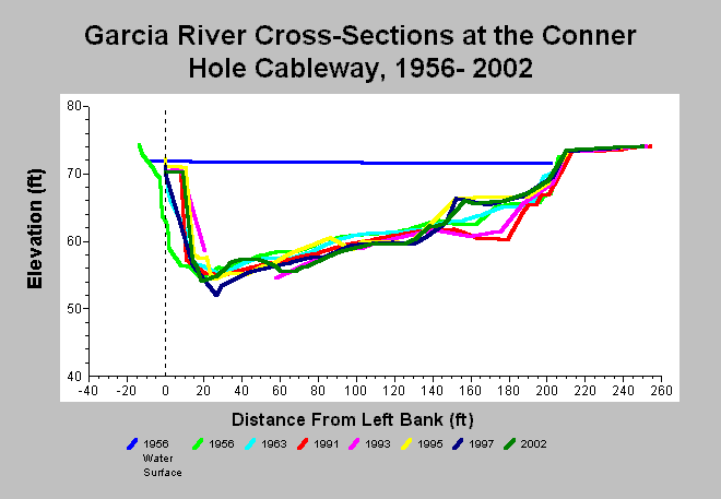
| Caption: This chart shows Garcia River cross-sections surveys conducted at the Conner Hole cableway between 1956 and 2002. Although this station is on the mainstem Garcia River, it is included because it falls within the North Fork Garcia Calwater Planning Watershed boundary. Surveys were conducted in 1956, 1963, 1991, 1995, 1997, and 2002 are shown. The point bar scoured between 1963 and 1991 but then built back up between 1993 and 1995. The thalweg scoured between 1995 and 1997. Although the channel filled slightly between 1997 and 2002, the pool remains well over ten feet deep and provides ample habitat for salmonid rearing and adult holding. The 2002 profile is also at the same approximate bed elevation as 1956. Data from the Mendocino County Water Agency. See InfoLinks for more information. | |
 |
To learn more about this topic click Info Links .
To view additional information (data source, aquisition date etc.) about this page, click Metadata .
To view the table with the chart's data, click Chart Table web page.
To download the table with the chart's data, click xs_garcia_connerhole_1956_2002.dbf (size 18,099 bytes) .
| www.krisweb.com |