
| Area | North Fork Garcia |
| Topic | Temperature: FWA Main Garcia River at Connor Hole 1995-2001 |
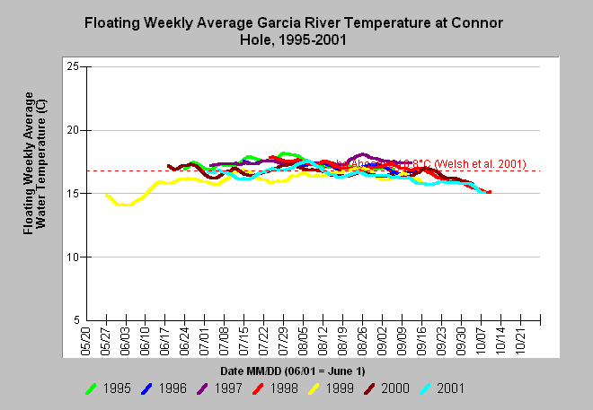
| Caption: This chart plots floating weekly average temperature of the Garcia River at Connor Hole for the years 1995-2001. This mainstem location is included in the North Fork sub-basin because of the Calwater boundary that includes the main Garcia below the North Fork. Floating weekly average temperatures exceeded 16.8 degrees Celsius during portions of all seven years measured. Temperatures in the years 1999-2001 were slightly lower than previous years, possibly due to riparian recovery below the North Fork. Welsh et al. (2001) found that coho are not likely to persist where maximum floating weekly average temperature (MWAT) exceeds 16.8°C. See InfoLinks for more information. Data provided by the Friends of the Garcia River and Mendocino County Water Agency. Click on Map to see locations of temperature monitoring stations. | |
 |
To learn more about this topic click Info Links .
To view additional information (data source, aquisition date etc.) about this page, click Metadata .
To view the table with the chart's data, click Chart Table web page.
To download the table with the chart's data, click temp_gar_dailyavg.db (size 352,256 bytes) .
| www.krisweb.com |