
| Area | South Fork Garcia |
| Topic | Land Cover: USFS Veg Size in Riparian for South Fork 1994 |
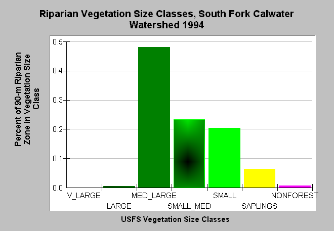
| Caption: This bar chart shows vegetation size classes in the riparian zone of the South Fork Calwater Planning Watershed. The riparian zone encompasses a distance of 90 meters (300 feet) on either side of the stream channel. This planning watershed had 49% of the riparian in medium-large and greater trees, 50% in small-medium and smaller trees and 1% in non-forest. The latter is partly the wide gravel bar of the mainstem Garcia, which runs through this sub-basin. The information was derived from a 1994 Landsat image by the U.S. Forest Service. This analysis technique calculates averages of vegetation stands at a one-hectare scale, and therefore is accurate at the stand rather than individual tree level. Click on InfoLinks for more information. Vegetation is classified according to diameter at breast height (DBH): Very Large = 40-50" DBH, Large = 30-39.9" DBH, Medium/Large = 20-29.9" DBH, Small/Medium = 12-19.9" DBH, Small = 5-11.9" DBH, Non-Forest = No trees, shrubs, grass, bare soil. | |
 |
To learn more about this topic click Info Links .
To view additional information (data source, aquisition date etc.) about this page, click Metadata .
To view the table with the chart's data, click Chart Table web page.
To download the table with the chart's data, click veg_usfs_rip_garcia.dbf (size 2,326 bytes) .
To view the table with the chart's source data, click Source Table web page.
To download the table with the chart's source data, click veg_usfs_rip_garcia_source.dbf (size 2,647 bytes)
| www.krisweb.com |