
| Area | South Fork Garcia |
| Topic | Sediment: Road Miles Inventoried 1998 and Treated 2000-01 in SF Garcia |
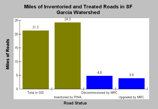
| Caption: This Chart compares the total miles of roads in the South Fork Garcia watershed with the miles of roads treated. The Total in GIS bar was calculated by KRIS staff using a California Department of Forestry 1:24,000 scale GIS roads layer (ridge top roads were not included). The number of miles inventoried was higher than the number of miles in the GIS layer because the GIS did not contain all roads. Approximately 36% of the roads inventoried were treated (either decommissioned or upgraded) by Mendocino Redwood Company in 2000 and 2001. Data on lengths of road inventoried, decommissioned, and upgraded were extracted from a report provided by the Trout Unlimited and Pacific Watershed Associates (2002). See InfoLinks for more information. | |
 |
To learn more about this topic click Info Links .
To view additional information (data source, aquisition date etc.) about this page, click Metadata .
To view the table with the chart's data, click Chart Table web page.
To download the table with the chart's data, click sed_road_sfgar_mrcpwatu_98_miles.dbf (size 238 bytes) .
| www.krisweb.com |