
|
Area/Topic | Bibliography | Background | Hypotheses | Home |
|
Map Page.
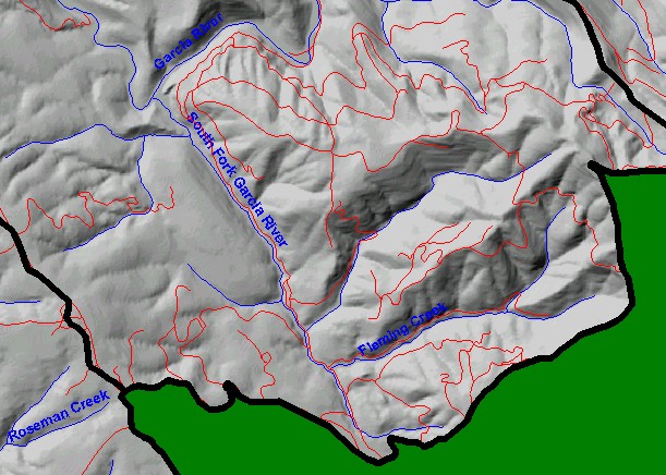
You selected the area South Fork Garcia and the topic Sediment: Road Miles Inventoried 1998 and Treated 2000-01 in SF Garcia |
| This is a map of the roads in the South Fork Garcia watershed. The roads data may under-represent actual roads because roads layers are only updated periodically and may not have newly constructed roads. Data were contributed by the California Department of Forestry, which compiled them from a variety of sources, including 1:24,000 scale U.S. Geologic Survey maps, and aerial photographs, | |||
|
|
||
To view metadata about a map layer, click on a link in the table below.
| Name of Layer in Map Legend | Metadata File Name |
|---|---|
| Sub-basins (no labels) | subbasins.shp.txt |
| Sub-basins (no labels) | subbasins.shp.txt |
| Project Frame | Unavailable |
| THP Roads (1:24k)(CDF) | roads_thp.shp.txt |
| Streams (1:24k scale)(w/ labels) | streams24.shp.txt |
| Topo Map (1:24k scale)(USGS) | Unavailable |
| Cold Spring, DOQ | coldspring.sid.txt |
| Eureka Hill, DOQ | eurekahill.sid.txt |
| Gualala, DOQ | gualala.sid.txt |
| Mallo Pass Creek, DOQ | mallopass.sid.txt |
| Ornbaun Valley, DOQ | ornbaun.sid.txt |
| Point Arena, DOQ | pointarena.sid.txt |
| Saunders Reef, DOQ | saundersreef.sid.txt |
| Grayscale Hillshade (TIFF) | grayscale.tif.txt |
| Project Background | Unavailable |
| www.krisweb.com |