
|

|
| Background | Hypotheses | Bibliography | Maps | Home |
|
|
|
| Background | Hypotheses | Bibliography | Maps | Home |
![]()
The Fort Ross rain gauge has an extremely invaluable record that spans back to 1872, except for 1875. When rainfall amounts are compared from 1872 to 1920, when old growth redwood forests covered the hills to the east, with rainfall from 1921-2000, there is a dramatic difference in the average annual total. In the 47 years measured between 1872-1920, the average rainfall was 54.18 inches annually which contrasts with an average of on 38.38 inches in the 79 years since. The other two long term rain gauge records in KRIS Gualala for Ukiah and Healdsburg do not show similar long term changes. The rain gauge type was changed in 1939 to a standard 8 inch model (USDC, 1955), which may have affected these averages. The decrease in rainfall averages is coincidental with conversion of old growth redwood forest to grasslands in the Gualala Basin just to the east between 1870 and 1920.
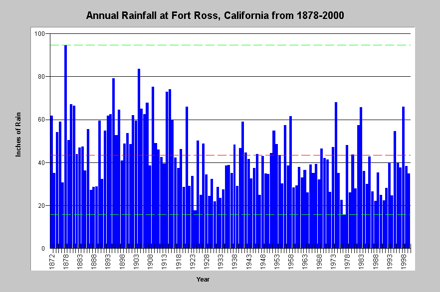 |
The graph above shows annual rainfall in inches in Fort Ross, California from 1872-2000, except for 1875 which was not recorded. Bounding lines show highest (94.75 inches) and lowest rainfall (16.01) totals with red line indicating mean annual rainfall (approximately 43 inches). In the 47 years measured between 1872-1920, the average rainfall was 54.18 inches annually which contrasts with an average of on 38.38 inches in the 79 years since. |
![]()
Reference
U.S. Department of Commerce. 1955. Fort Ross Substation History. National Oceanic and Atmospheric Administration, Weather Bureau. Memo by Carlos A. Carl, San Francisco, CA. 1 p.
![]()
| www.krisweb.com |