
| Area | Lower Klamath/Basin-wide |
| Topic | VegType: Blue Creek Lower vs Upper 1994 |
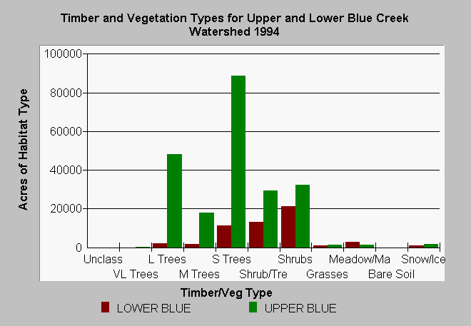
| Caption: The chart above shows vegetation types and timber size classes of the lower and upper Blue Creek watersheds as derived from a 1994 Landsat image. The Landsat image was classified using the WHR method by the Humboldt State University Spatial Analysis Laboratory then modified for use in KRIS (see Info Links). The upper Blue Creek watershed is in U.S. Forest Service ownership and timber harvest has been light as indicated by the number of acres with large trees. The substantial shrub and small tree component in upper Blue Creek may be owing to serpentine soils that can stunt vegetation. Much of the lower Blue Creek watershed is in early seral stage vegetation as a result of extensive logging on private industrial timberlands. See Pictures for aerial photos of upper and lower Blue Creek. Classes can be viewed below: Very Large Trees = 36" in diameter or greater Large Trees = 24-36" in diameter Medium Trees = 11-24" in diameter Small Trees = 6-11" in diameter Small Trees/Shrubs = Trees 1-6" in diameter and shrubs Shrubs Grass Rock/Soil Marsh/Meadow | |
 |
To learn more about this topic click Info Links .
To view additional information (data source, aquisition date etc.) about this page, click Metadata .
To view the table with the chart's data, click Chart Table web page.
To download the table with the chart's data, click kriseral.dbf (size 1,748 bytes) .
| www.krisweb.com |