
| Area | Lower Trinity/Basin-wide |
| Topic | Sediment: Lower Trinity - Road Densities 2001 |
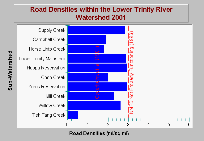
| Caption: This chart shows road densities in miles per square mile within the Lower Trinity River watershed as of (2001). Road densities do not exceed the properly functioning condition according to the National Marine Fisheries Service (1996), which is less than 3 miles per square mile; however, most sub-watersheds exceed Cederholm, et. al. (1981) suggested upper limit of 1.6 miles per square mile. Temporary roads and skid trails may not be represented in these data, which means estimates are conservative. Data provided by Matthews and Associates (2001). Click on Info Links for more background information. | |
 |
To learn more about this topic click Info Links .
To view additional information (data source, aquisition date etc.) about this page, click Metadata .
To view the table with the chart's data, click Chart Table web page.
To download the table with the chart's data, click sed_roads_lt_gma_2001.dbf (size 1,110 bytes) .
To view the table with the chart's source data, click Source Table web page.
To download the table with the chart's source data, click sed_roads_densities_erosion_trinity_pw_gma_2000.dbf (size 6,112 bytes)
| www.krisweb.com |