
| Area | Lower Trinity/Basin-wide |
| Topic | Sediment: Trinity River Watershed - Landslides by Geology 1944-2000 |
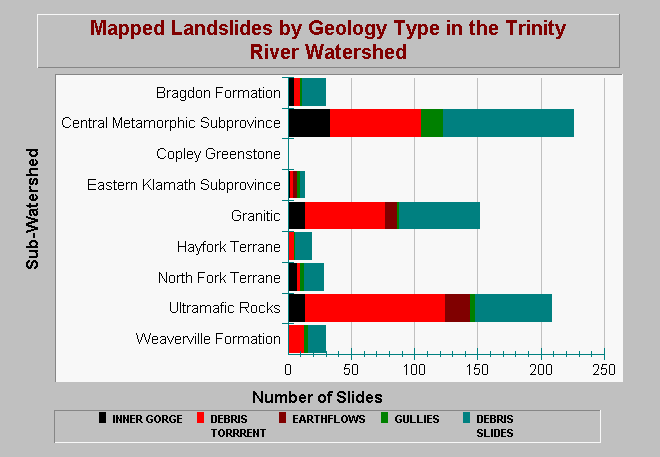
| Caption: This chart shows the number of landslides mapped by Graham Mathews and Associates (GMA) in different geologic terranes. The analysis covered a period from 1944 to 2000. GMA noted that the Central Metamorphic sub-province, ultramafic rocks, and granitic rocks account for about 82% of the landslides mapped. GMA did not map landslides in the Lower Middle Trinity, where the most of the Hayfork and North Fork Terranes are located, so it is not surprising that those two terranes have low numbers. These data confirm Department of Water Resource's general geologic instability analysis, which suggested that the Bragdon Formation, Copley Greenstone, and Eastern Klamath sub-province are all relatively stable terranes. Data are from GMA (2001). See Info Links for more information. | |
 |
To learn more about this topic click Info Links .
To view additional information (data source, aquisition date etc.) about this page, click Metadata .
To view the table with the chart's data, click Chart Table web page.
To download the table with the chart's data, click sed_slides_by_geo_trinity_gma.dbf (size 1,069 bytes) .
| www.krisweb.com |