
| Area | Mainstem Klamath |
| Topic | Fish: Chinook Redds/Reach, Totals 1994 |
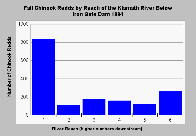
| Caption: The U.S. Fish and Wildlife Service has surveyed the Klamath River from below Iron Gate Dam to Happy Camp for fall Chinook salmon redds. This Chart shows the distribution of redds by reach in 1994. With a high number immediately below Iron Gate Dam, but with higher numbers around Happy Camp indicating wild Chinook salmon spawning. Scroll down for reach identification: 1: Iron Gate Dam to Ash Creek Access, 2: Ash Creek Access to Beaver Creek Riffle Access, 3: Beaver Creek Riffle Access to Blue Heron River Access, 4: Blue Heron River Access to Seiad Bar, 5: Seiad Bar Access to China Point, R 6: China Point to Indian Creek. | |
 |
To learn more about this topic click Info Links .
To view additional information (data source, aquisition date etc.) about this page, click Metadata .
To view the table with the chart's data, click Chart Table web page.
To download the table with the chart's data, click mkrd9396.dbf (size 1,238 bytes) .
| www.krisweb.com |