
| Area | Mainstem Klamath |
| Topic | Conductivity: Klamath Basin All Sites on Five Dates 1996 |
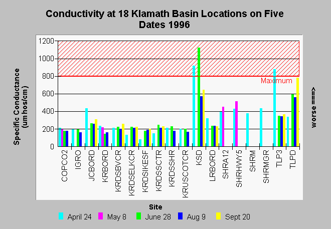
| Caption: The Chart above shows conductivity at various locations (key listed below) on different dates within the Klamath Basin in 1996. The maximum conductivity threshold shown is a North Coast Regional Water Quality Control Board standard. The highest conductivity readings were at stations in the Tule Basin and at the Klamath Straights Drain. See "Tour: Water Quality Sites on the Klamath" for photos of some locations. Site Key: TLP3=Tule Lake Pump 3 (in) TLPD=Tule Lake Pump D (out) JCBORD=J Canal at stateline LRBORD=Lost River at stateline KSD=Klamath Straits Drain at stateline KRBORD= Klamath River upstream of Shovel Creek COPCO2 = Copco Dam outflow IGRO=Iron Gate Dam outflow KRUSCOTCR = Klamath River upstream of Cottonwood Creek KRDSSHR= Klamath River downstream of Shasta River SHRA12=Shasta River at A-12 SHRMGR=Shasta River at Montague Grenada Road SHRHWY5=Shasta River downstream of Hwy 5 SHRM=Shasta River at mouth KRDSBVCR= Klamath River downstream of Beaver Creek KRDSSCTR = Klamath River downstream of Scott River KRDSELKCR = Klamath River downstream of Elk Creek KRDSIKESF = Klamath River at Ikes Falls KRWEITCH=Klamath River at Weitchpec | |
 |
To learn more about this topic click Info Links .
To view additional information (data source, aquisition date etc.) about this page, click Metadata .
To view the table with the chart's data, click Chart Table web page.
To download the table with the chart's data, click mh96cond.dbf (size 18,861 bytes) .
To view the table with the chart's source data, click Source Table web page.
To download the table with the chart's source data, click mh96a.dbf (size 85,264 bytes)
| www.krisweb.com |