
| Area | Mainstem Klamath |
| Topic | Temperature: Maximum Klamath Basin at 18 Sites 1996 |
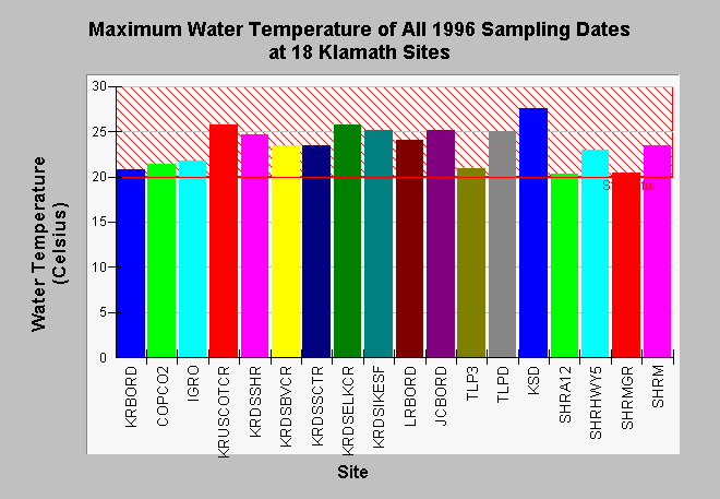
| Caption: The maximum water temperature of all sampling dates at eighteen Klamath Basin locations (see key below) is displayed above. Data were collected with hand held probes. The designation of stressful as 20 degrees Celsius pertains to salmonids, however, there are no salmonids at some locations such as those in the Tule Basin. See Info Links for more information. Site Key: TLP3=Tule Lake Pump 3 (in), TLPD=Tule Lake Pump D (out), JCBORD=J Canal at stateline, LRBORD=Lost River at stateline, KSD=Klamath Straits Drain at stateline, KRBORD= Klamath River upstream of Shovel Creek, COPCO2 = Copco Dam outflow, IGRO=Iron Gate Dam outflow KRUSCOTCR = Klamath River upstream of Cottonwood Creek KRDSSHR= Klamath River downstream of Shasta River SHRA12=Shasta River at A-12 SHRMGR=Shasta River at Montague Grenada Road SHRHWY5=Shasta River downstream of Hwy 5 SHRM=Shasta River at mouth KRDSBVCR= Klamath River downstream of Beaver Creek KRDSSCTR = Klamath River downstream of Scott River KRDSELKCR = Klamath River downstream of Elk Creek KRDSIKESF = Klamath River at Ikes Falls KRWEITCH=Klamath River at Weitchpec | |
 |
To learn more about this topic click Info Links .
To view additional information (data source, aquisition date etc.) about this page, click Metadata .
To view the table with the chart's data, click Chart Table web page.
To download the table with the chart's data, click mh96mima.dbf (size 5,672 bytes) .
To view the table with the chart's source data, click Source Table web page.
To download the table with the chart's source data, click mh96a.dbf (size 85,264 bytes)
| www.krisweb.com |