
| Area | Mainstem Klamath |
| Topic | Dissolved Oxygen: Klamath Basin All Sites on Four Dates 1996 |
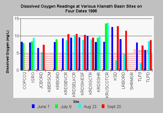
| Caption: The dissolved oxygen measurements taken at various Klamath Basin locations (sites are listed below) only fell into the range of stressful for fisheries at three locations: Lost River at Oregon border, Straights Drain and Tule Lake Pump 3. The time of sampling as indicated in the Source Table shows that few samples were taken in the early morning hours when the lowest D.O. readings can be expected (see Shasta Topic WQ: D.O. Nocturnal/Diurnal Changes). Site Key: TLP3=Tule Lake Pump 3 (in) TLPD=Tule Lake Pump D (out) JCBORD=J Canal at stateline LRBORD=Lost River at stateline KSD=Klamath Straits Drain at stateline KRBORD= Klamath River upstream of Shovel Creek COPCO2 = Copco Dam outflow IGRO=Iron Gate Dam outflow KRUSCOTCR = Klamath River upstream of Cottonwood Creek KRDSSHR= Klamath River downstream of Shasta River SHRA12=Shasta River at A-12 SHRMGR=Shasta River at Montague Grenada Road SHRHWY5=Shasta River downstream of Hwy 5 SHRM=Shasta River at mouth KRDSBVCR= Klamath River downstream of Beaver Creek KRDSSCTR = Klamath River downstream of Scott River KRDSELKCR = Klamath River downstream of Elk Creek KRDSIKESF = Klamath River at Ikes Falls KRWEITCH=Klamath River at Weitchpec | |
 |
To learn more about this topic click Info Links .
To view additional information (data source, aquisition date etc.) about this page, click Metadata .
To view the table with the chart's data, click Chart Table web page.
To download the table with the chart's data, click mh96do.dbf (size 18,745 bytes) .
To view the table with the chart's source data, click Source Table web page.
To download the table with the chart's source data, click mh96a.dbf (size 85,264 bytes)
| www.krisweb.com |