
| Area | Mainstem Trinity |
| Topic | Restoration: Trinity River - Historical Gravel Introduction Volumes |
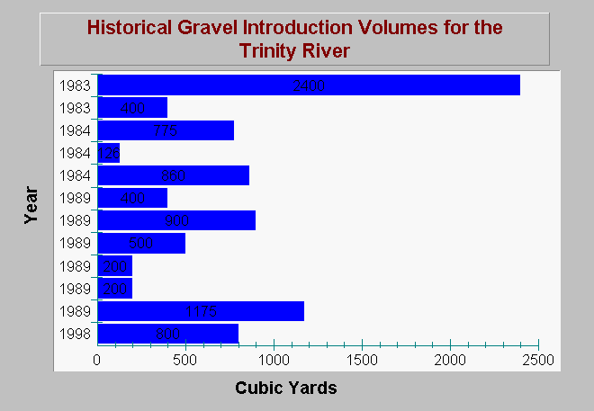
| Caption: This chart shows a subset of data on historic coarse sediment introduction efforts within the Trinity River, Lewiston Dam to Grass Valley Creek, 1983 to 1998. The entire data record extending from 1976 to 2002 is available in the Source Table. Gravel introduction efforts have been implemented for purposes of riffle construction and spawning gravel placement. Data are from the Draft Coarse Sediment Management Plan, Lewiston Dam to Grass Valley Creek Trinity River, CA (McBain and Trush, 2003). See Info Links for more information. | |
 |
To learn more about this topic click Info Links .
To view additional information (data source, aquisition date etc.) about this page, click Metadata .
To view the table with the chart's data, click Chart Table web page.
To download the table with the chart's data, click sediment_gravel_placement_short_mcbaintrush_2003.dbf (size 1,270 bytes) .
To view the table with the chart's source data, click Source Table web page.
To download the table with the chart's source data, click sediment_gravel_placement_mcbaintrush_2003.dbf (size 3,358 bytes)
| www.krisweb.com |