
| Area | Mainstem Trinity |
| Topic | Temperature: Floating Weekly Maximum Trinity River Sites 2003 |
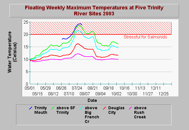
| Caption: This chart shows the floating weekly maximum water temperature (MWAT) of the Trinity River near the mouth, above the South Fork Trinity, above Big French Creek, at Douglas City, and above Rush Creek from May to October in 2003. Spatially, floating weekly average temperatures progressively get warmer downstream. This chart shows the floating weekly maximum temperature from just below Lewiston Dam (Rush Creek) to its convergence with the Klamath (Mouth). Trinity temperatures above Big French Creek receded below the stressful level in early August in response to flow releases at Lewiston Dam. Data are from the US Fish and Wildlife Service. See Info links for more information. | |
 |
To learn more about this topic click Info Links .
To view additional information (data source, aquisition date etc.) about this page, click Metadata .
To view the table with the chart's data, click Chart Table web page.
To download the table with the chart's data, click temp_klam_trin_usfws_2001_2003_daily_fwa.db (size 565,248 bytes) .
To view the table with the chart's source data, click Source Table web page.
To download the table with the chart's source data, click temperature_proxy.dbf (size 80 bytes)
| www.krisweb.com |