
| Area | Middle Trinity |
| Topic | Sediment: Lower Middle Trinity - Road Erosion by Source 2001 |
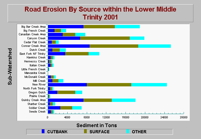
| Caption: The chart above shows computed active road erosion by type for the Lower Middle Trinity Watershed as of 2001. The different colored bars represent the various erosion source categories, while the total length of the bars show the total mass of sediment from all erosion sources. High sediment yields are a function of sub-watershed that contain high road miles. On average cutbank erosion yields the highest amounts of sediment, followed by surface erosion, and then other erosion sources. The data are from the Trinity River Sediment Budget Report (GMA 2001). See Info Links for methods and other background information. | |
 |
To learn more about this topic click Info Links .
To view additional information (data source, aquisition date etc.) about this page, click Metadata .
To view the table with the chart's data, click Chart Table web page.
To download the table with the chart's data, click sed_roads_lmt_gma_2001.dbf (size 2,314 bytes) .
To view the table with the chart's source data, click Source Table web page.
To download the table with the chart's source data, click sed_roads_densities_erosion_trinity_pw_gma_2000.dbf (size 6,112 bytes)
| www.krisweb.com |