
| Area | Middle Trinity |
| Topic | Sediment: Upper Middle Trinity - Sediment Transport Rates 2001 |
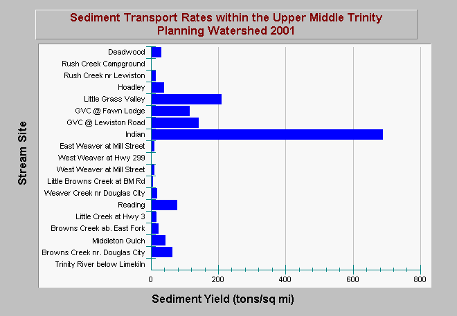
| Caption: This charts shows sediment transport yields in select streams for the 2001 water year in the Upper Middle Trinity River Planning Watershed. Sediment yields provide insight into the relative loading of various sub-watersheds with different levels of disturbance. Sub-watersheds with a WY2001 sediment load >100 tons/sq mi are considered to be highly disturbed and include Grass Valley Creek, and Indian Creek. The other sub-watersheds with sediment loads between 15-100 tons/sq mi are considered be moderately disturbed and includes most other watersheds. Reference watersheds have sediment load <12 tons/sq mi. The data also allow evaluation of upstream/downstream relationships in watersheds that have less disturbance in their upper watersheds. Such relationship are seen in Rush, Grass Valley, Weaver, and Browns Creeks. Note that WY2001 was an extremely dry year and it is not known whether these relationships would remain valid in other water year types or over a longer-term period. Data are from Graham Matthews and Associates (2001). See Info Links for more information. | |
 |
To learn more about this topic click Info Links .
To view additional information (data source, aquisition date etc.) about this page, click Metadata .
To view the table with the chart's data, click Chart Table web page.
To download the table with the chart's data, click sed_totaltransport_upmidtrinity_gma_2001.dbf (size 1,809 bytes) .
To view the table with the chart's source data, click Source Table web page.
To download the table with the chart's source data, click sed_totaltransport_trinity_gma_2001.dbf (size 2,489 bytes)
| www.krisweb.com |