
| Area | Middle Trinity |
| Topic | Sediment: Upper Middle Trinity - Slide Volumes by Land Use 1944-2000 |
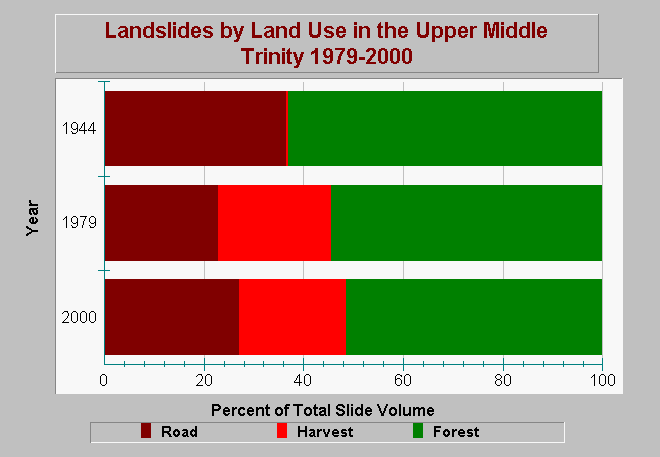
| Caption: This chart shows the percent of total sediment volume resulting from landslides in the Upper Middle Trinity River Planning Watershed. Landslides are categorized by land use associations that include categories of road, harvest, or forest. Road and harvest landslides are considered management related. Forest slides were identified in non-managed areas. Total Sediment production has increased in volume since the 1944 period. Road-related volumes declined from 37% in 1944, to 23% in 1979, but then increased to 27% in 2000. Harvest-related landslide volumes increase from essentially 0% in 1944, to 23% in 1979, and remained at 21% in 2000. Forest slides declined from 63% in 1944, to 54% in 1979, to 52% in 2000. Data are from Graham Matthews and Associated Trinity River Sediment Source Analysis (2001). See Info Links for more information. | |
 |
To learn more about this topic click Info Links .
To view additional information (data source, aquisition date etc.) about this page, click Metadata .
To view the table with the chart's data, click Chart Table web page.
To download the table with the chart's data, click sed_slides_type_uppermiddle_trinity_gma_1944_2000.dbf (size 719 bytes) .
To view the table with the chart's source data, click Source Table web page.
To download the table with the chart's source data, click sed_slides_type_pw_trinity_gma_1944_2000.dbf (size 1,385 bytes)
| www.krisweb.com |