
| Area | Middle Trinity |
| Topic | Timber Harvest: Upper Middle Trinity - Harvested Percent through 2000 |
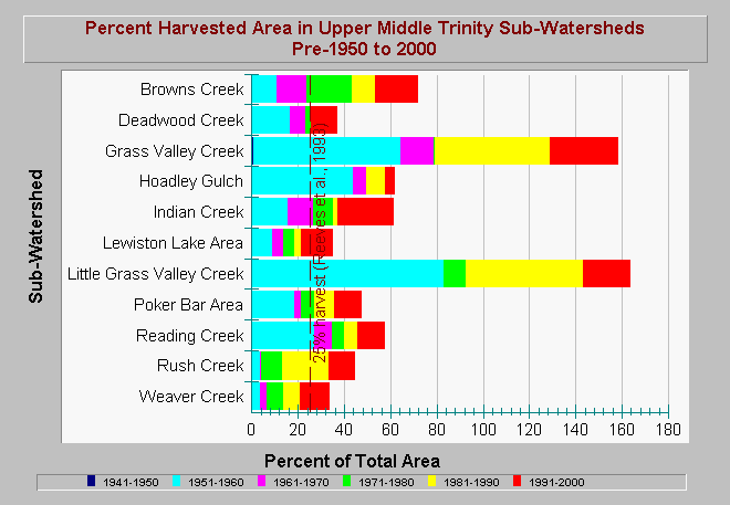
| Caption: This chart shows the percent of the total sub-watershed area that was harvested per decade within the Upper Middle Trinity Planning Watershed. The first time period category includes data prior to 1950. The different colored bars represent the percent area harvested per decade, while the total length of the bars show the cumulative percent area harvested during the period of pre-1950 to 2000. Note that harvest areas could have been re-entered during different decades. Two different harvest patterns are observed. Many sub-watersheds were intensively harvested in the 1950's. Harvest activity decreased between 1960 and 1980 and then increased in the most recent decades. Other sub-watersheds, such as Brown and Weaver creeks, have experienced constant harvest activity with percent harvested area increasing in decades that are more recent. Cumulatively, Grass Valley and Little Grass Valley creeks have been harvested over 150% by area. Reeves et al. (1993) noted that Oregon coastal watersheds logged in more than 25 percent of their area lost diversity of salmonid species. Data are from Graham Matthews and Associates Trinity River Sediment Source Analysis (2001). See Info Links for more information. | |
 |
To learn more about this topic click Info Links .
To view additional information (data source, aquisition date etc.) about this page, click Metadata .
To view the table with the chart's data, click Chart Table web page.
To download the table with the chart's data, click timberharvest_gma_upper_middle_trinity_1940_2000.dbf (size 3,450 bytes) .
To view the table with the chart's source data, click Source Table web page.
To download the table with the chart's source data, click timberharvest_gma_trinity_1940_2000.dbf (size 17,010 bytes)
| www.krisweb.com |