
| Area | Middle Trinity |
| Topic | Ownership: Upper Middle Trinity Land Ownership 2001 |
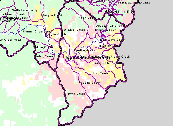
| This is a map of the land ownership in the Upper Middle Trinity Planning Watershed, displayed with sub-basin outlines and the mainstem and South Fork Trinity Rivers. The U.S. Forest Service (pale green) is the largest landowner in the sub-basin. The second-largest landowner is the Hoopa Tribe of California (reddish-brown) is located at the northwestern corner. Two industrial timber companies, Simpson Timber Company and Sierra Pacific Industries, own land in the basin. Data were produced by the Trinity County Resource Conservation District for the Graham Matthews and Associates Trinity River Sediment Source Analysis (2001). | |||
 |
 |
||
To view metadata about a map layer, click on a link in the table below.
| Name of Layer in Map Legend | Metadata File Name |
|---|---|
| Sub-Watersheds (TCRCD-GMA) | tr_wsbnd.shp.txt |
| Planning Watersheds (TCRCD-GMA) | tr_stdy-areas.shp.txt |
| Frame Project Outline | Unavailable |
| Mainstem and South Fork Trinity | trin_riv.shp.txt |
| Subbasin (no labels) | subbasins_trin.shp.txt |
| Trinity County Land Ownership | tc_gown.shp.txt |
| Humboldt County Land Ownership | hc_gov-own2.shp.txt |
| Topographic Map (1:24k scale) | trinity.sid.txt |
| Project Area Background | trin_outl.shp.txt |
| www.krisweb.com |