
| Area | Salmon River |
| Topic | Sediment: V* Salmon River Basin 1992 |
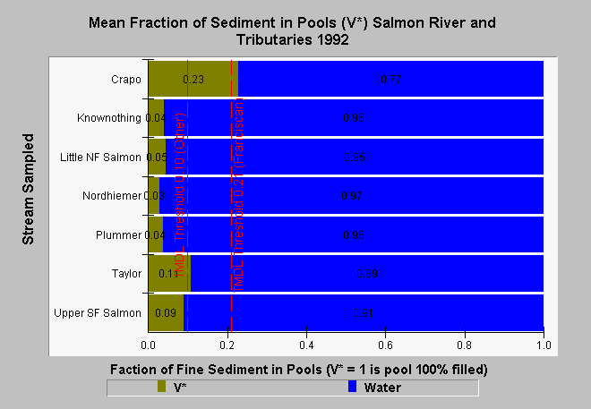
| Caption: This chart shows mean V* values for pools in the Salmon River and its tributaries in 1992. V* is the measure of the pool volume fraction that is filled by fine sediments. Levels of fine sediments in pools were low in many of the tributaries to the Salmon River in 1992. Taylor and Crapo creeks are two tributaries that continued V* values that exceeded typical target levels set by EPA TMDLs, which include: less than 21% for Franciscan geology and less than 10% for other geologic formations. These data were collected by the USFS Redwood Sciences Laboratory in Arcata, CA. See Info Links for more information. | |
 |
To learn more about this topic click Info Links .
To view additional information (data source, aquisition date etc.) about this page, click Metadata .
To view the table with the chart's data, click Chart Table web page.
To download the table with the chart's data, click sed_vstar_summary_salmon_1992.dbf (size 590 bytes) .
To view the table with the chart's source data, click Source Table web page.
To download the table with the chart's source data, click sed_vstar_source_usfsrsl.dbf (size 11,881 bytes)
| www.krisweb.com |