
| Area | Salmon River |
| Topic | Temperature: Temp Max Wooley Creek Longitudinal 1992 |
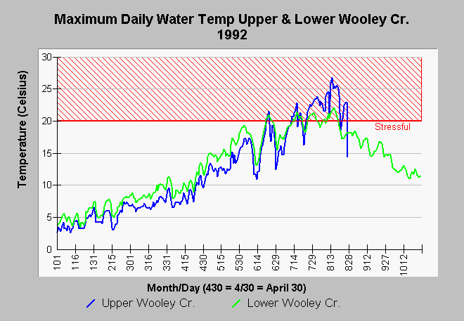
| Caption: This chart shows the maximum daily water temperatures in 1992 in upper Wooley Creek, below Bear Meadow, and lower Wooley Creek, 300 meters upstream of its convergence with the Mainstem Salmon River. Notice that water temperatures in upper Wooley Creek were cooler than lower Wooley Creek earlier in the season and warmer in mid summer. The Wooley Creek watershed is mostly in Wilderness areas and the warmer temperatures in upper Wooley Creek were probably owing to a reach that is naturally open to the summer sun. The 1992 water year was also very dry, which makes tributaries more subject to warming. Many of Wooley Creek's lower tributaries and the lower reaches of the creek itself are in a steep gorge shaded from the summer sun. Data were collected by automated temperature sensors called Hobotemps, which were anchored in moving water in the shade. Hobotemps were monitored by the Klamath National Forest, Salmon River Ranger District. Data were assimilated by Tim Mahan on behalf of the North Coast Regional Water Quality Control Board and provided to KRIS staff. | |
 |
To learn more about this topic click Info Links .
To view additional information (data source, aquisition date etc.) about this page, click Metadata .
To view the table with the chart's data, click Chart Table web page.
To download the table with the chart's data, click samaxdd.dbf (size 112,720 bytes) .
| www.krisweb.com |