
| Area | Scott River |
| Topic | Sediment: Proportion in Pools (V*) French Creek by Reach 1994 |
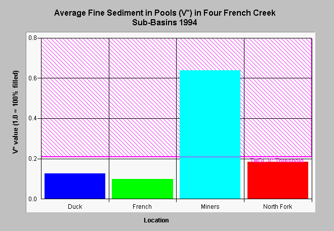
| Caption: The amount of fine sediment in pools has been measured for several years at different stations within French Creek. The results above depict average V* values for all pools measured within a sub-basin. The V* value is a ratio of the volume of fine sediment in a pool to the volume of water and fine sediment combined. In 1994, Miner's Creek had by far the highest level of fine sediment. French Creek just above the North Fork had the lowest fines in pools. Stations on Duck Lake Creek and the N. F. French Creek showed intermediate values. The TMDL threshold for V* (O.21) displayed on the chart was derived for the Garcia River and similar thresholds have not been established for the Scott Basin (see Info Links). Data provided by the U.S. Forest Service. | |
 |
To learn more about this topic click Info Links .
To view additional information (data source, aquisition date etc.) about this page, click Metadata .
To view the table with the chart's data, click Chart Table web page.
To download the table with the chart's data, click scv94a.dbf (size 226 bytes) .
To view the table with the chart's source data, click Source Table web page.
To download the table with the chart's source data, click vstar94.dbf (size 2,468 bytes)
| www.krisweb.com |