
| Area | Scott River |
| Topic | Temperature: 1994 Average Weekly Lower Scott and Canyon Creek |
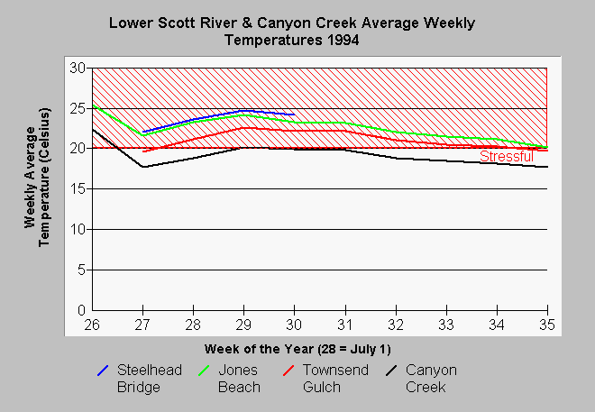
| Caption: This graph of average weekly temperatures at four locations in the Scott River basin is based on data collected by the USFS. One temperature probe was in Canyon Creek while the others were in the Scott River itself. The chart shows that temperatures were highest near the confluence of the Klamath at the Steelhead Bridge station. The Jones Beach station recorded the second highest range of temperatures. The Scott River below Townsend Gulch seems to have cooled as a result of the influence of cold tributaries such as Canyon Creek. Average weekly temperatures in Canyon Creek did not range much above 20 degrees C (68F), which is the temperature above which salmonids become cease growth. See Info Links for more information. | |
 |
To learn more about this topic click Info Links .
To view additional information (data source, aquisition date etc.) about this page, click Metadata .
To view the table with the chart's data, click Chart Table web page.
To download the table with the chart's data, click sctmwk94.dbf (size 1,203 bytes) .
To view the table with the chart's source data, click Source Table web page.
To download the table with the chart's source data, click sctcelc.dbf (size 241,643 bytes)
| www.krisweb.com |