
| Area | S.F. Trinity |
| Topic | Temperature: Maximum Hayfork @ 3 Hayfork Locations 1995 |
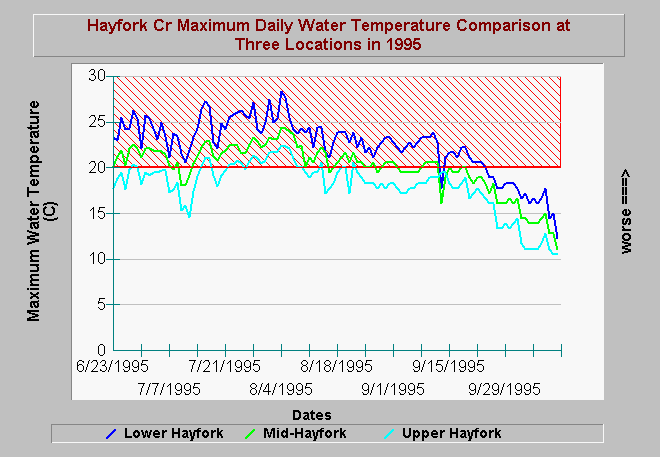
| Caption: Maximum water temperature measurements in Hayfork Creek in 1995 show a major increase in a downstream direction. While upper Hayfork Creek only exceeded stressful thresholds for salmonids for brief periods, maximum water temperatures near Hyampom consistently remained above stressful from June-September. Lower Hayfork is Hyampom, Mid-Hayfork is at Deep Gulch above Hayfork Valley and Upper is above Wildwood. Data collected by the Trinity County RCD and Weaverville office of the USDA Natural Resources Conservation Service. | |
 |
To learn more about this topic click Info Links .
To view additional information (data source, aquisition date etc.) about this page, click Metadata .
To view the table with the chart's data, click Chart Table web page.
To download the table with the chart's data, click hydayc.dbf (size 55,602 bytes) .
To view the table with the chart's source data, click Source Table web page.
To download the table with the chart's source data, click hyhobo.dbf (size 684,392 bytes)
| www.krisweb.com |