
| Area | S.F. Trinity |
| Topic | Temperature: Maximum Hayfork @ 3 NRCS Sites (01-03) 1996 |
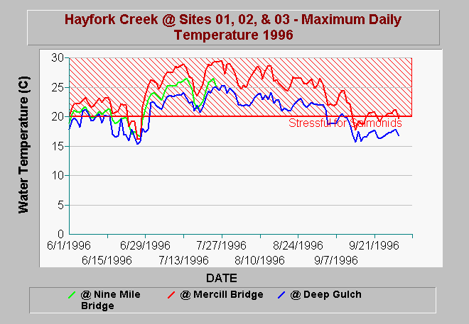
| Caption: The maximum daily water temperature of Hayfork Creek in 1997 at three NRCS monitored locations are shown above. Hayfork Creek is at acute stress or lethal levels at Mercill Bridge at the bottom of Hayfork Valley where agricultural impacts such as water diversion and poor riparian conditions contribute to degraded conditions. Although Hayfork below Deep Gulch is the coolest of the three locations monitored, it is well above stressful for salmonids. Agricultural diversion of Hayfork Creek also takes place above the East Fork, which depletes flows in this reach and makes the stream more subject to warming. Conditions at Nine Mile Bridge improve somewhat from those at Mercill Bridge but are still very poor for salmonids (see Higgins, 1995 in KRIS Bibliography). Data provided by NRCS Weaverville. See Picture for a map of gauge locations. | |
 |
To learn more about this topic click Info Links .
To view additional information (data source, aquisition date etc.) about this page, click Metadata .
To view the table with the chart's data, click Chart Table web page.
To download the table with the chart's data, click hfmax96.dbf (size 13,742 bytes) .
To view the table with the chart's source data, click Source Table web page.
To download the table with the chart's source data, click hf_temps.dbf (size 4,579,055 bytes)
| www.krisweb.com |