
| Area | S.F. Trinity |
| Topic | Temperature: Min, Max & Avg Hayfork (NRCS Site 01) @ 9 Mi. Bridge 1996 |
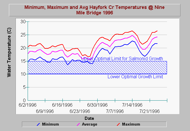
| Caption: The water temperature at Nine Mile Bridge on Hayfork Creek, below Hayfork Valley, reached stressful temperatures for salmonids early in June of 1996. By early July, conditions were acutely stressful with even the minimum water temperature above stressful. High water temperatures at Nine Mile Bridge may be in part exacerbated by water withdrawals and riparian conditions related to agricultural activities in Hayfork Valley upstream. Data collected by the Trinity County RCD and Weaverville office of the USDA Natural Resources Conservation Service. See Picture for a map view of gauge location. | |
 |
To learn more about this topic click Info Links .
To view additional information (data source, aquisition date etc.) about this page, click Metadata .
To view the table with the chart's data, click Chart Table web page.
To download the table with the chart's data, click tim2.dbf (size 2,106 bytes) .
To view the table with the chart's source data, click Source Table web page.
To download the table with the chart's source data, click hf_temps.dbf (size 4,579,055 bytes)
| www.krisweb.com |