
| Area | S.F. Trinity |
| Topic | Sediment: Road Densities - South Fork Trinity, GMA (2003) |
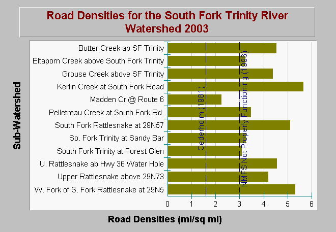
| Caption: The chart above shows road densities in miles per square mile within the South Fork Trinity River watershed as of 2003. The data are from the South Fork Trinity River Water Quality Monitoring Project. Road densities in most sub-watersheds exceed the properly functioning condition according to the National Marine Fisheries Service (1996), which is less than 3 miles per square mile and the salmonid survival reference determined by Cederholm et al. (1981). Data provided by Graham Matthews and Associates (2003). Click on Info Links for more background information. | |
 |
To learn more about this topic click Info Links .
To view additional information (data source, aquisition date etc.) about this page, click Metadata .
To view the table with the chart's data, click Chart Table web page.
To download the table with the chart's data, click road_density_sf_wshd_gma.dbf (size 1,062 bytes) .
To view the table with the chart's source data, click Source Table web page.
To download the table with the chart's source data, click sed_roads_densities_sf_trinity_gma_2003.dbf (size 4,930 bytes)
| www.krisweb.com |