
| Area | S.F. Trinity |
| Topic | Temperature: Maximum SF Trinity @ 5 Locations 1990 |
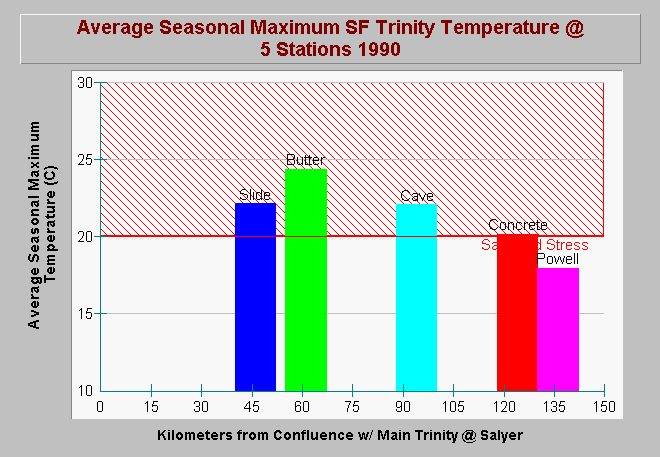
| Caption: Water temperatures on the South Fork Trinity River during the summer of 1990 showed an increasing trend in a down stream direction from Powell Creek to below Butter Creek. The water temperature at Slide Creek on the South Fork, however, drops slightly from that below Butter Creek. The later may be a result of hyporheic influences below Hyampom Valley. Increasing stream temperatures partially result from the orientation of the South Fork's channel, which catches the full arc of the summer sun. Channel widening and filling of the South Fork Trinity as a result of past sedimentation during the 1964 flood left some sections of the channel more open and subject to warming as well. Data provided by Shasta Trinity National Forest. See Picture for a map of gauge locations. | |
 |
To learn more about this topic click Info Links .
To view additional information (data source, aquisition date etc.) about this page, click Metadata .
To view the table with the chart's data, click Chart Table web page.
To download the table with the chart's data, click st6kma.dbf (size 303 bytes) .
To view the table with the chart's source data, click Source Table web page.
To download the table with the chart's source data, click sftr6km.dbf (size 450 bytes)
| www.krisweb.com |